Aldenard Mapping
A project to create detailed maps of Eorzea from Final Fantasy X!V
Map of Vylbrand and
La Noscea
Vylbrand: Mark 1.0
Details
A run-down of various important features and some tweaks I had to make in making the map
Future Developments
Plans for improving the map
Have feedback or suggestions for locations?
Contact: AWolfrider#8984
Map of Vylbrand: Version 1.0
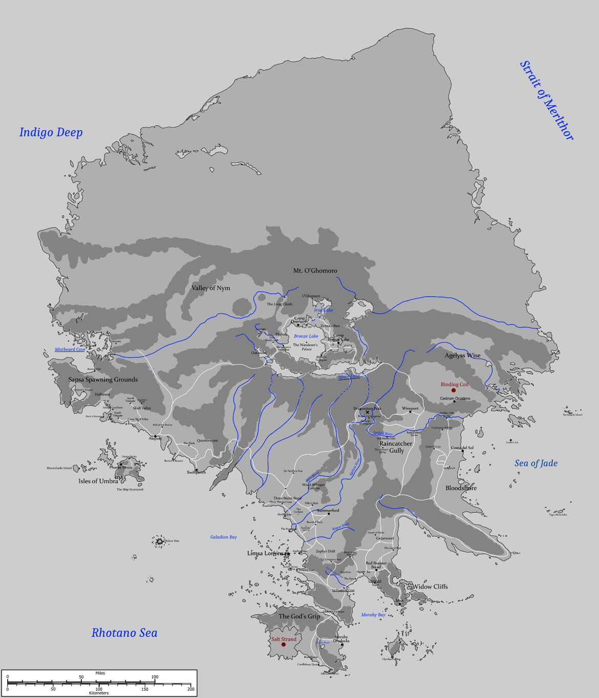
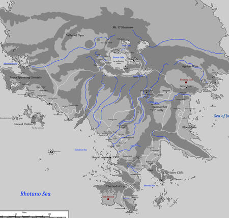
Please not that the rivers and maountains/hills marked on the map are only rough approximates for the most part right now. I will be fine tuning many elements with future versionsDesign: The goal of this project has been to preserve the ARR in-game zone maps with as little distortion as possible aside from size. These I combined with some maps of 1.0 La Noscea from Chrysalis to form the base of the map. I then took dozens of screenshots of each zone, mostly of the out-of-map areas to fill in the gaps. This is particularly hard it can be very hard to get good angles due to the low flight ceilings and very constrained boundaries of the maps. The different zones also have wildy different versions of the what lies between them. However, by combining screenshots from all six zones, Sastasha and Pharos Sirius dungeons, and the Leap of Faith's Floating City of Nym map from the Golden Saucer; I feel I’ve finally managed to cobble together something that is at least accurate to them all in spirit.Scale: I drew on this thread from Hydaelyn Roleplaters Coalition to come up with a scale for the map. However, I did size Vylbrand down a bit as based on those calculations and the in-game world map, the island would be 600 miles north to south. So I shrank it down by a third to make the distances in La Noscea a bit more managable. Thus on the map Vylbrand is 435 miles [700 km] from Oschon’s Torch to the northern tip of the island and about 350 miles [563 km] at its widest point. From this I’ve estimated a very approximate area of 90,000 sq. miles [233,100 sq. km], roughly the size of Honshu Island.
Comparison with in-game zones
Details
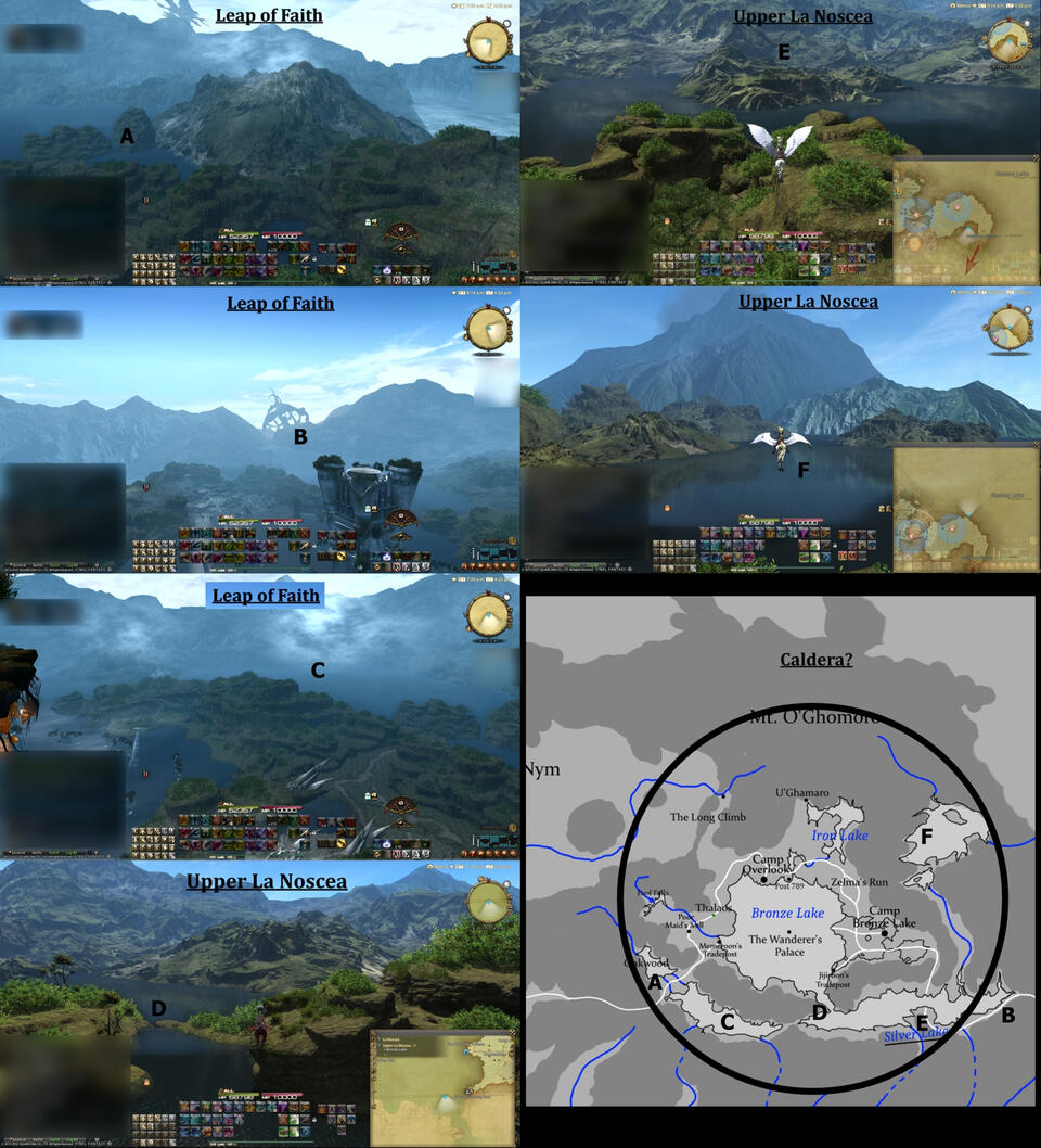
O’Ghomoro and Bronze Lake: The lakes around the Upper and Lower La Noscea region is based primarily on what can be seen on the Floating City of Nym map from the Leap of Faith GATE. The Upper La Noscea map shows a very large lake to the northwest and west that connects to the southern one, but I scaled it down due to difficulties plotting its size and overall shape.The Caldera Theory: Based on the orientation of the mountains around Upper and Lower La Noscea, I wonder if Mt. O’Ghomoro could actually be sitting on the north side of an ancient caldera of a much more massive volcano. This volcano could have been one that erupted during the Second Umbral Calamity. The peak then collapsed and a new peak gradually rose on it’s northern slopes, becoming O’Ghomoro. Extensive Kobold tunneling in the area could then have combined with the upheavals caused by the Seventh Calamity to further collapse parts of the caldera, forming the lakes as they are today. Kobold tunnels could also allow the lakes to now drain through the mountains to the lower parts of La Noscea.
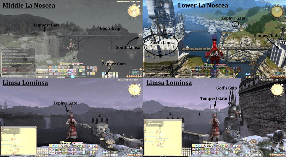

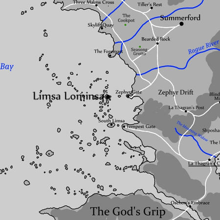
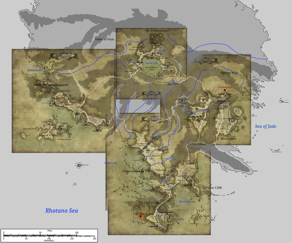
Galadion Bay: Galadion Bay is one of the regions I changed the most. Limsa has been drastically sized down compared to it’s size on the in-game maps to bring to a more realistic size. Due to this, Tempest Gate has been moved furter north The maps for Limsa, Middle La Noscea, and Lower La Noscea all have very different designs for the coast between Zephyr Gate and the God’s Grip. What I settled on is a mix of Middle and Lower’s designs. In addition, The Foremast has been moved much further south to the mouth of the Agelyss River to keep it close to the city.
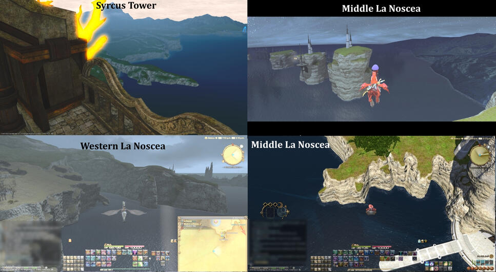
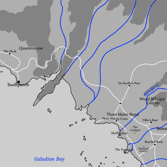
Quarterstone to Three Malm Bend: This was one of the trickiest regions to design. Western La Noscea’s in-game map shows a penninsula between it and Middle La Noscea that loosely matches the 1.0 based maps but no real clues as to what is on its other side. Middle La Noscea shows what could be a peninsula some distance to it’s north but too vague to be of any real use. However, you go to the final boss area in Pharos Sirius, you can see the coastline of Western and Middle Coastlines. While it’s very vague in some areas, especially where the Three Malm Bend region is, I was ultimately able to draw on this version to tie the two zones together.
Of particular note, Pharos Sirius appears to show the southern face of the peninsula to be a tall cliff between Western and Middle.
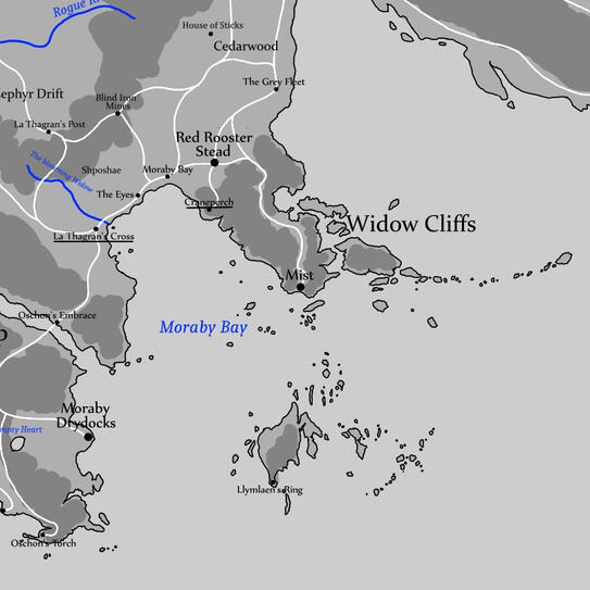
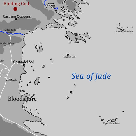
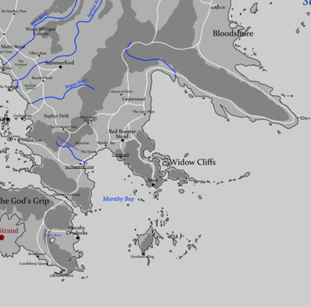
Widow Cliffs: The lighthouse of Lymlaen’s Ring appears to still exist post-Calamity on an island east of Moraby Drydocks, albeit further east than in 1.0. On the map I pulled relocated it to it’s approximate original location. While the Lower La Noscea map does also show the remnant of the Widow Cliffs peninsula where Mist is located, but it’s very simplistic so I put it together based on 1.0 based maps. All the smaller islands I added around Mist and Lymlaen’s Ring aren’t shown on the ARR’s maps aside from a few immediately around the Ring and three that can be seen from Mist but it seems likely that some other bits of the old peninsula would remain as shattered island chains.In a similar vein I’ve used 1.0 island names for some islands off the coast of Bloodshore. 1.0 maps and the official map of the Three Great Continents shows several large islands in the area, though the ARR in-game maps show only a few tiny ones close to the shore. Thus I’ve elected to retain some remnants of those islands, albeit ravaged by the Calamity like the Widow Cliffs. Names are very approximate, especially since there’s nothing I can find to say where Locke’s Lie and Turtleback Island were back then.